Dún Beag Fort Visitor Centre
https://dunbeagfort.com/history-of-dun-beag-fort/
Fahan, Dingle, Co. Kerry, Ireland : Tel: +353 66 915 9070 : Email: info@dunbeagfort.com
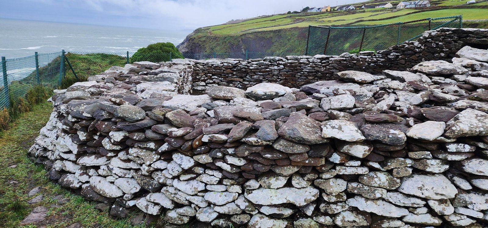
During my December 2023 jaunt along the Dingle Peninsula in County Kerry Ireland, I discovered this remarkable prehistoric fort called the Dun Beag Fort. In Irish this means “Little Fort”. It is a triangular shaped promontory fort measuring 35m along its western side atop the 30 m high cliffs on the Dingle Peninsula in County Kerry with distinctive rows of defences and panoramic views over the Dingle Bay of Valentia Island and the Skellig Isles. Originally the defenses are said to have been built during the Iron Age but the fort was used up until the 10th century. Many antiquarians and geologists have written about it and it has become a popular tourist destination since the 20th century. Originally it was recorded by George Du Nover in 1856. Unfortunately through time it has been vandalized and altered, with hare hunters overturning stones and materials taken for buildings locally. Some drystone field walls were also built across the fort’s banks and ditches that were later removed by the Office of Public Works (OPW) restoration in 1892. The roof of one of the two guard chambers that was located on either side of the rampart wall entrance was repaired while the western guardhouse no longer exists. January 2014 a storm collapsed the southern side of the entrance through the rampart.
fort divided the point of a headland from the main shore with a dry stone wall roughly 15-25 feet (4.6 and 7.6 m) in width and about 200 feet (61 m) long from one side of the headland to the other. A passage from the midpoint leads through the wall roughly 3.5 feet (1.1 m) high, 2 feet (.61 m) wide at the top, 3 feet (0.91 m) at base wit ha 7 feet (2.1 m) long lintel. Passage widens to 8 feet (2.4 m) inside the fort wit than arched ceiling. Fort’s wall cut off access to the triangular promontory which was later occupied by a single large beehive hut. Other group of clocháns, small stone structures or beehive huts nearby were built around 1000 B.C.E. In front of the defensive wall are four parallel ditches separated by three clay and gravel mounds. A pathway leads through the defenses to the entrance of the fort.
Also, over 3 m of land has fallen to the sea over the last 20 years along the western edge. The site was excavated in 1977 by the OPW and National Monuments Service with professor Terry Barry of Trinity College Dublin attempting to date the remains before more was lost to the sea. They discovered post holes, hearths, and stake holes within the clochán with suggestions of wattle shelters having been supported by wooden posts and stakes. Occupational debris excavated indicated a diet of pigs, goats, sheep, deer, cattle, birds, and fish. Radiocarbon dates suggest inhabitation from 10th-11th c. C.E. with further excavations of the rampart revealing a earlier shallower ditch radiocarbon dated to 6th c. B.C.E. Wood sample in the ditch laying partly under the stone dated to 580 B.C.E. Another piece of wood in a deposit overlayinig the base of a retaining wall dated to 800 C.E.
References and additional information:
- Dun Beag 2023 History of Dun Beag Fort. Website referenced 12/16/24 at https://dunbeagfort.com/history-of-dun-beag-fort/
- Wikipedia 2023 Dun Beag Fort. Website referenced 12/16/24 at https://en.wikipedia.org/wiki/Dunbeg_Fort


 2025: Thomas Baurley.")
 2025: Thomas Baurley.")
 2025: Thomas Baurley.")
 2025: Thomas Baurley.")
 2025: Thomas Baurley.")
 2025: Thomas Baurley.")
 2025: Thomas Baurley.")
 2025: Thomas Baurley.")
 2025: Thomas Baurley.")
 2025: Thomas Baurley.")
 2025: Thomas Baurley.")
 2025: Thomas Baurley.")
 2025: Thomas Baurley.")
 2025: Thomas Baurley.")
 2025: Thomas Baurley.")
 2025: Thomas Baurley.")
 2025: Thomas Baurley.")

 2025: Thomas Baurley.")
 2025: Thomas Baurley.")
 2025: Thomas Baurley.")
 2025: Thomas Baurley.")
 2025: Thomas Baurley.")
 2025: Thomas Baurley.")
 2025: Thomas Baurley.")
 2023: Thomas Baurley.")
 2023: Thomas Baurley.")
 2023: Thomas Baurley.")
 2023: Thomas Baurley.")
 2023: Thomas Baurley.")
 2023: Thomas Baurley.")
 2023: Thomas Baurley.")
 2023: Thomas Baurley.")
 2023: Thomas Baurley.")
 2025: Thomas Baurley.")
 2025: Thomas Baurley.")
 2025: Thomas Baurley.")
 2025: Thomas Baurley.")
 2025: Thomas Baurley.")
 2025: Thomas Baurley.")
 2025: Thomas Baurley.")
 2025: Thomas Baurley.")
 2025: Thomas Baurley.")
 2025: Thomas Baurley.")
 2025: Thomas Baurley.")
 2025: Thomas Baurley.")
 2025: Thomas Baurley.")
 2025: Thomas Baurley.")
 2025: Thomas Baurley.")
 2025: Thomas Baurley.")
 2025: Thomas Baurley.")
 2025: Thomas Baurley.")
 2025: Thomas Baurley.")
 2025: Thomas Baurley.")
 2025: Thomas Baurley.")
 2025: Thomas Baurley.")
 2025: Thomas Baurley.")
 2025: Thomas Baurley.")
 2025: Thomas Baurley.")
 2025: Thomas Baurley.")
 2025: Thomas Baurley.")
 2025: Thomas Baurley.")
 2025: Thomas Baurley.")
 2025: Thomas Baurley.")
 2025: Thomas Baurley.")
 2025: Thomas Baurley.")
 2025: Thomas Baurley.")
 2025: Thomas Baurley.")
 2025: Thomas Baurley.")
 2025: Thomas Baurley.")
 2025: Thomas Baurley.")
 2025: Thomas Baurley.")
 2025: Thomas Baurley.")
 2025: Thomas Baurley.")
 2025: Thomas Baurley.")
 2025: Thomas Baurley.")
 2025: Thomas Baurley.")
 2025: Thomas Baurley.")


 2024: Thomas Baurley.")
 2024: Thomas Baurley.")
 2024: Thomas Baurley.")
 2024: Thomas Baurley.")
 2024: Thomas Baurley.")
 2024: Thomas Baurley.")
 2024: Thomas Baurley.")
 2024: Thomas Baurley.")
 2024: Thomas Baurley.")
 2024: Thomas Baurley.")
 2024: Thomas Baurley.")
 2024: Thomas Baurley.")
 2024: Thomas Baurley.")
 2024: Thomas Baurley.")
 2024: Thomas Baurley.")
 2024: Thomas Baurley.")
 2024: Thomas Baurley.")
 2024: Thomas Baurley.")
 2024: Thomas Baurley.")
 2024: Thomas Baurley.")
 2024: Thomas Baurley.")
 2024: Thomas Baurley.")
 2024: Thomas Baurley.")
 2024: Thomas Baurley.")
 2024: Thomas Baurley.")
 2024: Thomas Baurley.")
 2024: Thomas Baurley.")
 2024: Thomas Baurley.")
 2024: Thomas Baurley.")
 2024: Thomas Baurley.")
 2024: Thomas Baurley.")
 2024: Thomas Baurley.")
 2024: Thomas Baurley.")
 2024: Thomas Baurley.")
 2024: Thomas Baurley.")
 2024: Thomas Baurley.")
 2024: Thomas Baurley.")
 2024: Thomas Baurley.")
 2024: Thomas Baurley.")
 2024: Thomas Baurley.")
 2024: Thomas Baurley.")
 2024: Thomas Baurley.")
 2024: Thomas Baurley.")
 2024: Thomas Baurley.")
 2024: Thomas Baurley.")
 2024: Thomas Baurley.")
 2024: Thomas Baurley.")
 2024: Thomas Baurley.")
 2024: Thomas Baurley.")
 2024: Thomas Baurley.")
 2024: Thomas Baurley.")
 2024: Thomas Baurley.")
 2024: Thomas Baurley.")
 2024: Thomas Baurley.")
 2024: Thomas Baurley.")
 2024: Thomas Baurley.")
 2024: Thomas Baurley.")
 2024: Thomas Baurley.")
 2024: Thomas Baurley.")
 2024: Thomas Baurley.")
 2024: Thomas Baurley.")
 2024: Thomas Baurley.")
 2024: Thomas Baurley.")
 2024: Thomas Baurley.")
 2024: Thomas Baurley.")
 2024: Thomas Baurley.")
 2024: Thomas Baurley.")
 2024: Thomas Baurley.")
 2024: Thomas Baurley.")
 2024: Thomas Baurley.")
 2024: Thomas Baurley.")
 2024: Thomas Baurley.")
 2024: Thomas Baurley.")
 2024: Thomas Baurley.")
 2024: Thomas Baurley.")
 2024: Thomas Baurley.")
 2024: Thomas Baurley.")
 2024: Thomas Baurley.")
 2024: Thomas Baurley.")
 2024: Thomas Baurley.")
 2024: Thomas Baurley.")
 2024: Thomas Baurley.")
 2024: Thomas Baurley.")
 2024: Thomas Baurley.")
 2024: Thomas Baurley.")
 2024: Thomas Baurley.")
 2024: Thomas Baurley.")
 2024: Thomas Baurley.")
 2024: Thomas Baurley.")
 2024: Thomas Baurley.")
 2024: Thomas Baurley.")