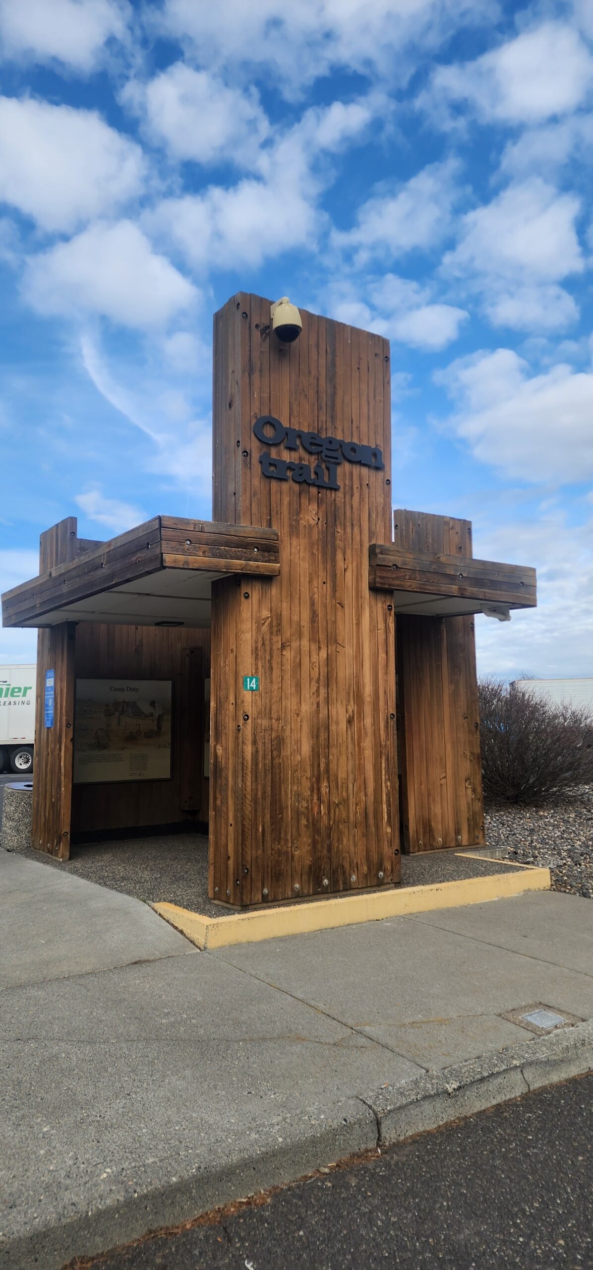
The Oregon Trail – La Grande to Baker City, Oregon
I remember growing up hearing about the Oregon Trail as a video game, then come graduation I drove part of it when I headed to the West Coast. The Oregon Trail is a pioneer trail that extends approximately 2,170 miles from the Eastern to the Western United States. It was used by large-wheeled wagons by primarily Euro-American settlers heading West before the railways were built. It was originally carved by trappers and fur traders from 1811 until 1840, only passable by horseback and foot. The first wagon trail was cleared from Independence, Missouri to Fort Hall, Idaho, and eventually to Willamette Valley, Oregon. The modern-day states that the trail passed through were Iowa, Missouri, Kansas, Nebraska, Wyoming, Idaho, and Oregon. Since its 1811 inception, the trail grew and expanded with trails to roads, cutoffs, bridges, and ferries were established. Then it died when the rails brought settlers via train faster and more safely. It is believed that between 1846 and 1869 over 400,000 pioneers followed the trail with over 10% of which died along the journey. The Oregon Trail was used to access other immigrant trails such as the California Trail in 1843, Mormon Trail in 1847, and Bozeman Trail in 1863. The First Transcontinental Railroad was finished by 1869 diminishing its use. Federal Interstate highways were later established for motorized vehicles creating faster, safer travel along Interstates 80 and 84 west.

The great explorer Meriwether Lewis was assigned to “explore the Missouri River, and such principal stream of it, as, by its course and communication with the waters of the Pacific Ocean, whether the Columbia, Oregon, Colorado or another river may offer the most direct and practicable water communication across this continent, for commerce.” Lewis teamed up with fellow explorer William Clark, following Thomas Jefferson’s 1803 order to find a route to the Pacific Ocean. This route eventually was carved into the Midwest through the Wild West as the Oregon Trail. It became Mullan Road in 1859 connecting the Missouri River with the Columbia River. With the advent of motorized vehicles, it became Interstate 80 and 84.
1804-1809:
Lewis and Clark mapped the route between 1804 and 1806 believing they found a practical overland route to the West Coast. Their original route traversing the Rocky Mountains involving Lolo Pass and Lemhi Pass was too difficult for wagons to safe passage through, so during their return trip in 1806 they followed the Columbia River to the Snake River, and Clearwater River over Lolo pass, upland to the Blackfoot River crossing the Continental Divide onwards to the Missouri River which roved much faster. They ran into other difficulties with this route as it was affected by the Blackfoot Indians and was very rough for wagons. They stated there was no easy route through the northern Rockies. They successfully mapped the Eastern and Western river valleys which gave birth to the Oregon Trail to cross the continental divide. The Trail eventually used the South Pass which was not traveled by Lewis and Clark originally. It was a tough trail and many reports back East told of the journey as rough. Even Lieutenant Zebulon Pike in 1806 said the Great Plains were “unfit for human habitation.
1810-1815:
In 1810, the Pacific Fur Company found a need for a better route and initiated much of the original trailblazing for the Oregon Trail. The Pacific Fur Company was founded by John Jacob Astor as a subsidiary of his American Fur Company in the Pacific Northwest. They initially set up operations along the Columbia River. They established two expeditions, one by the Tonquin and the other by Wilson Price Hunt to establish supply routes and trapping territories. The Tonquin crew built Fort Astoria min March 1811 along the Columbia, leaving supplies and staff while exploring further north along the Pacific coast to Clayoquot Sound. The ship was destroyed by the Tl-o-qui-aht elder of the Clayoquot, and the surviving interpreter Quinault informed Fort Astoria of the tragedy. Meanwhile, Hunt continued upland south of Lewis and Clark’s route within what is modern-day Wyoming, passing across Union Pass into what is now Jackson Hole. They crossed over the Tetons down through the Snake River into what is now Idaho. They used the Snake River for transport finding steep canyons, waterfalls, and impassable rapids. They walked the rest of the way to the Columbia River where they made boats and arrived at Fort Astoria. They proved that much of the Snake River and Columbia could be passed by foot, horse, mule, or wagon with improvements made. This eventually became segments of the Oregon Trail.
The Pacific Fur Company sent a team back east retracing the overland expedition’s trail with Robert Stuart in charge. However, they feared attacks near Union Pass and re-routed further south where they discovered South Pass, making transit much easier. They went further east using the Sweetwater River, North Platte River, and the Platte River to the Missouri River making a landing in St. Louis. This proved to be an effective wagon route, and in 1813 began development and use. The War of 1812 caused a lack of interest in treading west for fear of safety, access, and viability.
While this had occurred, separately the British North West Company had an expedition led by David Thompson exploring much of western Canada and the Columbia River. After mapping out possible fur trading posts, they floated down the Columbia River to Fort Astoria and camped at the confluence of the Columbia and Snake Rivers. They laid claim for Britain to build a fort on the site. Fort Astoria felt threatened so sold their supplies and establishment to the North West Company in 1812. Development was then taken over by the North West Company. Once the War of 1812 ended with the Treaty of Ghent, the Oregon territory was given back to the United States.
1816-1824:
But struggles between the United States and Canada persisted even though it was officially “joint occupation” of the region, officially by the Anglo-American Convention of 1818. The British discouraged U.S. trappers from establishing themselves in the region.
Then in 1821, the British government had the North West Company merge with Hudson’s Bay Company to squash rivalry, establishing a monopoly on trading in Oregon. British parliament gave the district and company power to enforce the laws as if it were part of Canada. They took near full control of the Pacific Northwest from 1812 until 1840. This included the western half of the Oregon Trail. This was tested in 1824 when American missionaries and settlers began arriving in Oregon. Fort Vancouver in Washington began expansion in 1824 upstream of Fort Astoria becoming the central hub for the Pacific Northwest greeting ships from London to the Pacific via Cape Horn. Furs, supplies, and goods were traded here. Major Stephen Long in 1819 warned settlers that the Great Plains were the Great American Desert with a lack of timber and surface water, sandy wastelands with vast herds of bison that somehow managed to live there.
Before the massive emigration hit the West and developed the Oregon Trail, most of the explorers were fur traders and trappers. The trappers worked for the traders, exploring all water sources with a lot of attention on beaver. Some of the most famous were Kit Carson, Jim Bridger, Peter Skene Ogden, Manuel Lisa, Robert Stuart, William Henry Ashley, Jedediah Smith, William Sublette, Alexander Ross, James Sinclair, Andrew Henry, Donald Mackenzie, Thomas Fitzpatrick, David Thompson, James Douglas, all of whom were trailblazers who kept good journals of their travels, hired out as consultants and guides. They helped blaze the trail.
1825-1839:
By 1825 the Hudson Bay Company began utilizing two brigades from each end of the express route, the York Factory on Hudson Bay and the other from Fort Vancouver via the Columbia River. During this time the York Factory Express created another route from Fort William Ontario to Fort Astoria, Oregon. Each Spring they would pass one another in the Midwest and create a quick journey one way to resupply its forts and fur trading centers within 100 days covering the 2600-mile one-way route. The Hudson Bay Company created Fort Colvile on the Columbia River near Kettle Falls to control the upper Columbia River fur trade. They built Fort Nisqually by where present-day DuPont, Washington is located taking vantage of Puget Sound.
From 1832-1834, Captain Benjamin Bonneville explored a good portion of what became the Oregon Trail, bringing wagons up the Platte, North Platte, Sweetwater across South Pass to the Green River of Wyoming. His explorations detailed most of the Trail to the Columbia through Idaho which was later published by Washington Irving by 1838.
Reverend Jason Lee established the Methodist Mission in the Dalles, Oregon by 1834 along the Columbia River. Marcus Whitman and Henry H. Spalding went west establishing the Whitman Mission near where Walla Walla, Washington exists. These were amongst the first notable Missionaries taking the Oregon Trail for God. Many husband and wife missionaries took to the trail on wagons establishing missions along the way.
Thomas Farnham and his band of 18 men called the “Oregon Dragoons” left Peoria, Illinois in 1839 to colonize Oregon on behalf of the United States with the intent to drive out the Hudson Bay Company, and were amongst the first pioneers to traverse most of the Oregon Trail – “Oregon Or The Grave” was imprinted on their flag they carried.
1840-1860:
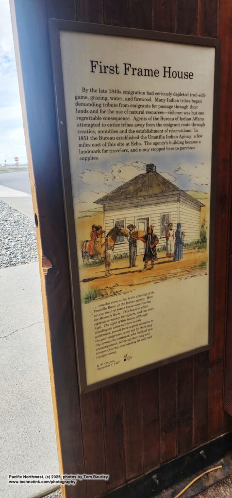
Along the Trail, many settlers did not make it, and some gave up along the journey settling where they found themselves destitute or broken. Many refused to stop in the Great Plains, even in the 1840s, because it was land illegal for homesteading as it was set aside by the government for the Native Americans (until at least 1846). Oregon was painted out to be free for the taking and was fertile, disease-free, uncut, and unclaimed, with big rivers and potential seaports. The British were not seen as a threat. By the 1840s thousands of emigrants arrived, outnumbering the British. Fort Vancouver (now modern-day Washington State) was a central influence for the fur and trade industry with influence spreading from the Rocky Mountains to the Hawaiian Islands and Russian Alaska to Mexico-controlled California. By 1840 it was recorded to have over 34 outposts, 24 ports, 6 ships, and over 600 staff. This monopoly was challenged with Euro-American settlers came over the Oregon Trail having their final destination at Fort Vancouver where they would get their sundries, aid, and assistance to begin homesteading in Oregon and Washington state.
Disputes between the United States and Canada were overwhelming. The Hudson Bay Company was primarily defending itself with three forts – Fort Hall, Fort Boise, and Fort Nez Perce on the west end of the Oregon Trail. The fur trade began to slow down in 1840. James Sinclair led 200 settlers in 1841 from the Red River Colony near present-day Winnipeg into the Oregon territory. The plan failed as most of the families joined those in the Willamette Valley under the promise of free land and a Hudson Bay Company free government.
It wasn’t until the fall of 1840 that the first wagons made the Columbia River over land and officially opened the final leg of the trail to wagons, by Robert Newell, and Joseph Meek with their families to Fort Walla Wall. The first emigrants headed West using the full Oregon Trail was the Bartleson-Bidwell Part in 1841 setting out for California, but half the party went to Oregon instead of California leaving their wagons at Fort Hall going different ways at Soda Springs, Idaho. The 2nd organized wagon trail left Elm Grove, Missouri in 1842 with 100 pioneers led by Elijah White – and they broke up at Fort Hall as well.
Kit Carson guided three expeditions from 1842-1846 detailing California and Oregon for the U.S. Army Corp of Topographical Engineers for John C. Fremont that became widely published. By 1843 Hudson Bay headquarters was established at Fort Victoria covering all operations in British Columbia. This was the birthing moment for present-day Victoria.
The “Wagon Train of 1843” a.k.a. “The Great Migration of 1843” brought nearly 1,000 emigrants to Oregon via the Oregon Trail, led first by John Gantt – a former U.S. Army Captain and fur trader. The biggest obstacle at the time was past the Blue Mountains of Oregon where they had to cut and clear a trail through heavy timber, stop at the Dalles in Oregon, disassemble their wagons, float them down the Columbia River while the animals were headed over the rough Lolo Trail to pass Mt. Hood. This blazed the Trail to become passable for wagons from the Missouri River to the Dalles.
The lands within Oregon Country were claimed by settlers in the Willamette Valley, drafting the Organic Laws of Oregon in 1843 – granting married couples free land up to 640 acres, and unmarried settlers 320 acres, though these claims were not valid under British nor United States law. Eventually, they were honored by the United States in 1850 under the Donation Land Act granting married settlers 320 acres and unmarried ones 160 acres. By 1854 the land was no longer given free but sold at the rate of $1.25 an acre.
By 1846 the struggles came to a head and the Oregon Treaty was written ending the Oregon boundary dispute. The British lost land north of the Columbia River and a new Canadian – United States border was established north at the 49th parallel. The Canadians received good anchorage at Vancouver and Victoria, the United States a reasonable boundary and good anchorage in Puget Sound. The United States tested everything by pushing more settlers into the future state of Washington outnumbering the British.
They completed the Barlow Road around Mount Hood in 1846 providing a rough but completely passable wagon trail from the Missouri River to the Willamette Valley.
In 1844 the Mormons witnessed the assassination of the prophet Joseph Smith as well as persecution in Missouri, Illinois, and parts of the Midwest. This led their leader Brigham Young to Salt Lake Valley in 1847 with over 2,200 pioneers to establish settlements and create a base camp for future emigration for the church. In 1848 thousands of emigrants joined them bringing many women and children. From 1847 to 1860 over 43,000 Mormons traveled on the Oregon Trail as well as the California Trail to Utah. They established the Mormon Trail with trail improvements and ferries for those following them.
By 1848 gold was discovered in the Sierra Nevada giving birth to the California Gold Rush. Approximately 2/3 of Oregon males went to California in 1848 by the lure of gold. They created the Lassen Branch of the Applegate-Lassen Trail cutting a wagon road through the forest, bringing back gold to finance Oregon’s economy. This lured many from the East Coast and the Midwest onto the Oregon and California Trail, calling themselves the “forty-niners” in a mad dash across the country, sacrificing safety for speed and taking shortcuts. This was the year when the cholera epidemic had struck the United States causing thousands to die along the trail.
Use of the trail declined by 1855 once the railways were established, the first of which was the Panama Railroad across the Isthmus of Panama as well as paddle wheel steamships and sailing ships carrying goods and people from the East Coast and New Orleans to and from Panama to ports in Oregon and California. Ferries were built along many rivers on the Oregon Trail, increasing populations across the Americas.
By 1859 the U.S. Army made improvements along the Trail for wagons and stagecoaches, after the Civil War the Pony Express was established around 1860 having riders on horses with relay stations every 10 mils along the trail from St. Joseph, Missouri to Sacramento California. Most of these stations were built along the Oregon Trail, Mormon Trail, Bozeman Trail, and California Trail.
1861-1880:
Around this same time, the First Transcontinental Telegraph began laying lines along the Central Overland Route, with several stage lines for mail and passengers traveling day and night – getting settlers to California from the Midwest in 25-28 days. The Pony Express was closed down by 1861. The First Transcontinental Railroad was finished in 1869. The Oregon Trail was heavily used from the Missouri River to the Columbia River for miners, farmers, lumberjacks, ranchers, and business opportunities – with two-way traffic. By 1870 populations along the trail increased by over 350,000 settlers. The trail was also used to drive herds of thousands of livestock to various towns along the route.
With the railroad, the journey took seven days and cost approximately $65. The trail was taken over by highways and railroads eventually turning into U.S. Highway 26, Interstate 84, and Interstate 80.
References
- BLM 2016 “Basic Facts About the Oregon Trail”.
- Dary, David 2004 “The Oregon Trail: An American Saga”.
- Hanson, T. J. 2001 Western Passage”.
- Johnson, Randall 1995 “The Mullan Road: A Real Northwest Passage”.
- Rollins, Philip 1995 “The Discover of the Oregon Trail: Robert Stuart’s Narratives of His Overland Trip Eastward from Astoria in 1812-1813.”
- State of Oregon n.d. Rest Area historical information signs
- Unruh, John David 1979 “The Plains Across: The Overland Emigrants and the Trans-Mississippi West, 1840-1860”. University of Illinois Press.
- Wikipedia n.d. “The Oregon Trail”. Website referenced 5/25/21 at https://en.wikipedia.org/wiki/Oregon_Trail
 2025: Thomas Baurley.")
 2025: Thomas Baurley.")
 2025: Thomas Baurley.")
 2025: Thomas Baurley.")
 2025: Thomas Baurley.")
 2025: Thomas Baurley.")
 2025: Thomas Baurley.")
 2025: Thomas Baurley.")
 2025: Thomas Baurley.")
 2025: Thomas Baurley.")
 2025: Thomas Baurley.")
 2025: Thomas Baurley.")
Oregon Trail Tales: Pioneers, Perils, and the Path That Shaped America
Imagine standing on the edge of a dusty frontier town in the 1840s, surrounded by oxen, wagons, and enough bacon to stock a small diner. You’re about to embark on the journey of a lifetime—a grueling, 2,000-mile trek across untamed wilderness, with everything you own packed into a rickety wooden cart. Welcome to the Oregon Trail, where dreams of a better life collide with the harsh realities of survival. For the pioneers who dared, the stakes couldn’t have been higher: would they conquer the journey and stake their claim, or lose it all to the perils of the path? This trail wasn’t just a route; it was the backbone of westward expansion, a gamble of hope, courage, and a whole lot of grit.
The Birth of the Oregon Trail
Imagine thick forests, untouched mountains, and rivers that roared louder than the wagons creaking through the wilderness. Before the Oregon Trail became a bustling highway of hope for pioneers, it was rugged, uncharted territory. The path we now call the Oregon Trail wasn’t created in a day—it was pieced together through years of exploration, trade, and sheer grit. So, who were these early trailblazers, and how did their efforts lead to one of the greatest migrations in American history? Let’s peel back the layers and meet the key players.
The Pathfinders: Fur Traders and Trappers
Before the Oregon Trail was a trail, it was just an idea—and that idea sprouted from fur traders and trappers, the original outdoor adventurers. These men weren’t looking for a shortcut to the West; they were chasing furs, specifically beaver pelts, the 19th century’s version of cryptocurrency. Their business revolved around the booming demand for hats and fashion trends back East.
In their quest for pelts, trappers such as Jedediah Smith and Kit Carson unwittingly mapped out basic routes that future pioneers would follow. They didn’t have GPS or Yelp reviews to guide them—just instincts and the occasional tip from Indigenous tribes. These paths crisscrossed rivers, skirted mountain passes, and skirted buffalo herds. You could say the fur traders didn’t open a door to the West—they pushed it ajar just enough for settlers to peek through.
The fur trade wasn’t just a business—it was a way of life. It brought eclectic characters together and, unfortunately, forever altered relationships with Native American tribes. Learn more about the fur trade’s impact and dynamics in this detailed article on Fur Trade in Oregon Country.
Missionaries and the Call to Settle
While fur traders were busy hauling beaver skins, missionaries were planting something a little more eternal—faith. Individuals like Marcus and Narcissa Whitman didn’t just dream of spreading Christianity; they envisioned communities blooming in the West.
Marcus Whitman, a physician-turned-missionary, significantly shaped early settler migration. In the 1830s, he and his wife Narcissa established a Presbyterian mission among the Cayuse people near modern-day Walla Walla, Washington. But there’s more to Marcus than his sermons. In 1843, he helped lead a thousand settlers along the Oregon Trail, proving the path was navigable for entire families. Families could now picture a new life, complete with schools, farms, and a fresh start—all thanks to those wagon ruts in the dirt.
The Whitmans’ work wasn’t without its challenges. Tensions with the Cayuse people and eventual tragedy marked their journey, yet their contribution to westward expansion is undeniable. This detailed biography on Marcus Whitman outlines his life’s impact.
The Oregon Trail wasn’t built overnight. Fur traders mapped the way by chasing profit, and missionaries laid the groundwork for settler communities. Together, they turned imagination into tangible paths, setting the stage for the flood of wagons about to follow. Each hoofprint, wagon wheel, and footstep carved history into the land.
The Journey West: A Grueling Adventure
The Oregon Trail wasn’t just a route; it was a test of endurance, determination, and often sheer luck. It pushed thousands of brave souls to their physical and mental limits. Every mile brought new challenges, whether it was crossing a swollen river, climbing unforgiving mountains, or simply figuring out how to survive another day. Let’s explore some of the harsh realities that turned this journey into one of the 19th century’s most unforgiving adventures.
The Art of Packing: What Made the Wagon Roll
Packing for the Oregon Trail wasn’t like packing for a weekend camping trip. This was survival 101. Pioneers had to fit everything they would need for months into a single wagon. Think of it as playing Tetris, but with your entire life on the line.
So, what made the cut? The essentials fell into a few key categories:
- Food staples: Flour, bacon, beans, and coffee were the backbone of trail meals. Some families carried hundreds of pounds of these items to ensure they didn’t run out mid-journey. Biscuits, lard, and dried fruits were also common. If it wasn’t shelf-stable, it wasn’t coming along.
- Cooking tools: Cast iron cookware, especially skillets and Dutch ovens, was indispensable. Forget Instant Pots—this was as rustic as it gets.
- Survival gear: Think tools like axes, ropes, and repair kits for wagons. Guns and ammunition were must-haves for hunting and protection. Pioneer wagons didn’t come with spare parts, so every bolt and pin mattered.
- Animals: Oxen were the workhorses of the Oregon Trail. Strong and reliable, they kept the wagons rolling (literally). Horses and mules were less common but still vital for some families.
But it wasn’t just about food and tools. Families also packed their dreams. They carried heirlooms, keepsakes, and precious items that reminded them of home. Want to learn more about what pioneers packed? Check out this fascinating Packing for the Oregon Trail Guide.
Battling the Elements: Weather, Rivers, and Mountains
Mother Nature was one tough customer on the Oregon Trail. Travelers faced searing heat, bone-chilling cold, and torrential rain—all in the same week. And that was just the beginning.
- Rivers: Crossings were a nightmare. Swollen rivers could swallow wagons whole, and many lives were lost to drowning or capsized rafts. Settlers often relied on makeshift ferries or Indigenous guides for help.
- Mountains: The trek through the Rockies was grueling, but South Pass provided a relatively easy way through. Still, the high altitude and rugged terrain weren’t exactly a leisurely hike.
- Storms and droughts: Violent weather could delay travel for days, while lack of water through arid stretches pushed people and animals to the brink.
The Oregon Trail wasn’t for the faint-hearted. Each environmental challenge was a stark reminder of the Wild West’s raw and untamed beauty. To get a deeper understanding of the hazards pioneers faced, this Britannica entry on the Oregon Trail sheds light on their struggles.
Disease and Death: Oregon Trail’s Dark Shadows
If the elements didn’t get you, disease might. The Oregon Trail was a breeding ground for calamities, with illness lurking around every corner. One of the most notorious killers was cholera, a bacterial infection that caused severe dehydration. Dysentery wasn’t far behind, and the symptoms were equally brutal. These diseases were often spread by contaminated water sources, turning every sip into a potential death sentence.
Accidents were another grim reality. Wagon rollovers, hunting mishaps, and even routine chores could turn fatal. And if someone became seriously injured, finding medical care was next to impossible. Doctors were few and far between, and the remedies of the day often did more harm than good.
Despite the hardships, pioneers pushed forward. Their determination was astounding, though many paid the ultimate price. Intrigued by the grim realities of trail life? Read more about The Diseases of the Oregon Trail.
Cultural Impact and Historical Significance
The Oregon Trail wasn’t just a road. It was a lifeline to opportunity, a shared pulse of American dreams, and the cornerstone of westward expansion. From the incredible migration of 1843 to groundbreaking land laws, this trail etched itself into the cultural and historical foundation of the United States.
The Great Emigration of 1843
Imagine packing your entire life into a wagon, gathering your courage, and stepping into the unknown with thousands of strangers who shared your dream. That’s precisely what happened in May 1843, when close to 1,000 pioneers gathered in Independence, Missouri, to form what we now call the “Great Emigration.” This wasn’t just a casual road trip; it was the catalyst that proved mass migration westward was viable. With the wagons stretching on for miles, this marked the first large-scale usage of the Oregon Trail.
Why was 1843 such a big deal? Up until this migration, the Oregon Trail was primarily used in smaller numbers, and people weren’t sure if wagons could handle the entire journey. But under the guidance of leaders like Marcus Whitman, families successfully trekked 2,000 miles through treacherous terrain and harsh climates. This journey showed the hopeful but hesitant that a better life was possible across the horizon.
Over time, this event became symbolic of American resilience and determination. Curious to learn more about this historic migration? Read this overview on the Great Emigration.
Land Laws and Settlement Opportunities
If the Oregon Trail was the ride, the Oregon Donation Land Act of 1850 was the big “OPEN” sign on the destination. This law was a game-changer, offering settlers free land in exchange for establishing homes and farming. You heard that right: free land. Single settlers could claim 320 acres, while married couples could claim a whopping 640 acres. In today’s terms, that’s like being handed a large farm for just showing up.
Why did it matter? Passing this act increased not just the region’s population but also its strategic importance to the United States. It was a bold statement: “This territory belongs to us—and we intend to use it.” Of course, the law played a significant role in shaping the development of Oregon, but it wasn’t without controversy. After all, this “free land” came at the expense of Indigenous peoples who lived there long before settlers arrived.
Want to dive deeper into how these policies shaped Oregon’s identity? This in-depth look at the Oregon Donation Land Act breaks it all down beautifully.
End of the Trail: From Wagons to Rails
The Oregon Trail, once the lifeline for pioneers, didn’t last forever in its golden age. While it played a critical role in westward expansion, technological advances ushered in a new era. The wagons may have started the journey west, but the roar of locomotives soon made them obsolete. Let’s uncover how the relentless march of progress replaced this historic path and how its legacy remains alive today.
The Railroad Revolution: From Oregon Trail to the Iron Rails
By the mid-19th century, covered wagons ruled the road—well, the dirt path. They were slow, clunky, and prone to everything from busted axles to devastating cholera outbreaks. But in 1869, the completion of the Transcontinental Railroad marked the beginning of the end for the Oregon Trail. Suddenly, a journey that once took months could now be completed in mere days, all while sitting in (somewhat) padded seats. Goodbye oxen, hello streamlined, iron-clad speed machine.
The impact was immediate. With railroads crisscrossing the country, settlers no longer needed to endure grueling months of trekking thousands of miles. Supplies could be shipped directly, towns grew along the railways, and the lure of the trail as a necessity melted away. This seismic shift revolutionized westward migration. Think of it like upgrading from flip phones to smartphones—it changed everything overnight. Interested in the role railroads played? Check out The History of Oregon Trail’s Decline via Railroads.
However, not all was lost for the trail. Even though it was no longer the go-to migration route, its stories, landmarks, and rugged beauty endured. For a deeper dive on how the railroad took over America, this history of the Transcontinental Railroad draws an engaging picture of that transformation.
Preserving the Legacy: Oregon Trail as a National Treasure
Fast-forward to 1981—a pivotal year for trail enthusiasts and history buffs. Congress officially designated it as the Oregon National Historic Trail, ensuring its preservation for generations. If the trail had been Instagram-worthy in its prime, this would’ve been its blue-check moment.
Why does this matter? Today, the Oregon Trail isn’t just a faded memory—it’s a vibrant symbol of the grit and determination that defined American pioneers. Hikers can walk portions of the trail, exploring landmarks like Chimney Rock and Fort Laramie. Folks can even road trip alongside it (minus the risk of dysentery). It stands as both a cultural and historical treasure.
Much of this preservation effort focuses on educating the public. Museums, commemorative sites, and even old wagon ruts keep the Oregon Trail alive and relevant for curious travelers. Want to learn more about its designation and role today? The National Park Service has a comprehensive guide on the Oregon National Historic Trail.
So, while the Oregon Trail’s wagons have been parked permanently, its story barrels on—much like those trains that replaced it.
Conclusion
The Oregon Trail isn’t just a route etched into maps; it’s a testament to human tenacity and the pursuit of opportunity. Every wagon wheel rattle and dusty mile tells a story of bold ambition, unyielding hope, and collective perseverance—a legacy that continues to inspire.
Today, as we marvel at the courage of those who faced unimaginable obstacles, the trail invites us to reflect on what we’re willing to overcome for our dreams. Whether you’re exploring its historic ruts or striving for your modern “Oregon,” this chapter of history reminds us that progress often starts with a daring first step.
So, what’s your next frontier?